

December 30, 2017
The Atlantic Ocean… still awesome, still relentless, still unforgiving. Our first offshore passage (technically possibly more of a coastal passage) had taken us a maximum of twenty miles offshore. We certainly felt a sense of accomplishment; we had been tested in many ways. Yet we recognized these tests had actually been quite restrained in their scope. We still respected Poseidon enough to feel fear during the drama of lowering our mainsail.
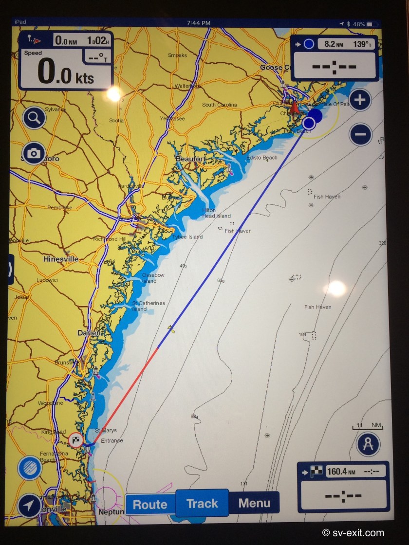
A second offshore passage, just days after our first, hopefully was more a testimony to our enthusiasm than overzealous ambition. From Charleston, SC we hoped to get all the way to St. Marys, GA, just over 150 nautical miles away.
The timing on this voyage would be much more hit and miss regarding how far we could get. Although we expected not to be more than twenty five nautical miles offshore, we anticipated both wind and waves would be facing us much more than following us this time, so we weren’t so confident in our ability to make good time. If progress was too slow, we needed a bailout inlet to fall back upon so we could avoid arriving at St. Marys after dark.
We regretted not having our staysail sorted out on our last passage. Months before, we had set it up once, but never had actually sailed with it.
Last time, we had the benefit of tailwinds, which allowed us to get away with using the genoa sail in winds that, probably, were too strong for that amount of sail. This time, the wind would be in front of us, so having the smaller staysail available could prove invaluable. Better to furl the genoa and utilize the staysail in heavier winds than lose momentum having to sail under mainsail alone, or heel over excessively and get an extra pounding because we left the genoa up too long. We made sure to rig the inner forestay and running backstays, as well as set up the staysail on deck in preparation.
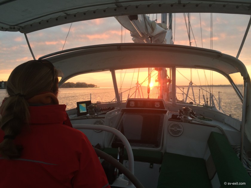
We got up before sunrise so that we would be ready to start pulling up anchor as soon as it was light enough. As the sun began to peak over the horizon, we motored slowly away from the graveyard of sailboats we had anchored next to and headed for the Charleston Inlet… and, once again, the Atlantic Ocean.
Exit Log:
07:15 – Anchor up at Charleston Bay – 5-8kts of wind but still managed to make 9.7kts with a favorable 3kt current.
09:00 – Outside the inlet channel ahead of time. Engine off; 9-11kts of wind on starboard beam; gently rolling 1ft seas; making 5-7kts
10:30 – Winds dropped to 5-9kts; making 3.5-5kts
14:00 – Winds have picked up to 10-15kts but having trouble maintaining 5kts forward speed as wind keeps closing inside of 30-40 degrees to our bow, plus 1/2 knot current against us. Warm sun and clear skies but wind has a bitter bite and is coming from almost 90 degrees south of where we expected it.
15:00 – Still having to edge 10-15 degrees offshore farther than intended to maintain a sailing angle on these winds.
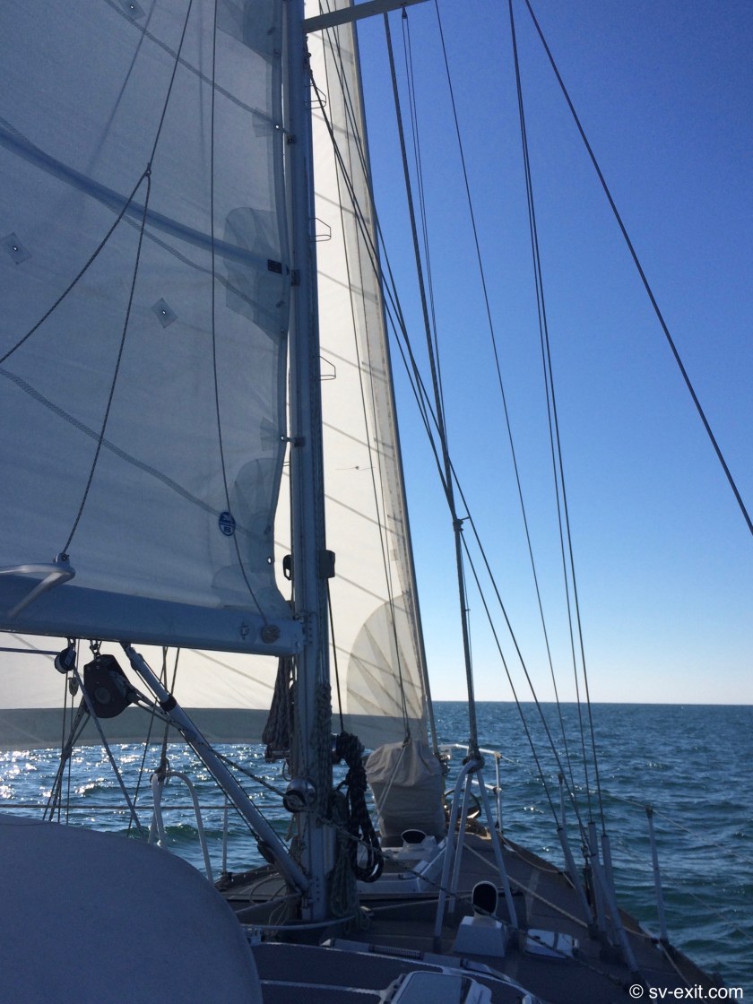
16:30 – Family of dolphins with baby joined us for about ten minutes playing just off the bow… incredible! 16kts of wind dead on our bow; to get outside of 30 degrees for sails having to point at the land or the ocean. Furled the genoa and raised the staysail (for the first time under way) in case the wind finally clocks around to the north and potentially increases in strength.
19:00 – Currently 25nm offshore; already 5nm further out than planned. Winds steady at 17-18kts on our bow; seas building but bigger waves still spaced quite far apart. Don’t want to head any further out so having to head for shore to try to improve our angle – means no forward progress until we tack again. With engine running, still having trouble maintaining 3-4kts, plus 1kt of opposing current has us making only 2.5kts of forward progress. Not sure if we’re feeling the edge of the Gulf Stream or not.
21:00 – Watch change. Just shy of a full moon is creating spectacular visibility tonight. Wind hitting 21kts. Having to reef the main while still needing to motor… crazy!
24:00 – Midnight. Seas are definitely starting to settle down; wind now 13-16kts. Finally our speed indicator is showing 6kts but still losing a knot to current. Keeping motor-sailing for now to try to salvage possibility of reaching St. Marys tomorrow. Not warm but no longer frigid… yay!
02:00 – Mostly rolling seas; wind has FINALLY shifted to starboard beam and dropped to 11-12kts. Now making good at 6kts course over ground even with the 1kt current still against us. Need to shake out the main reef and adjust the staysail at watch change. Lost autohelm connection repeatedly for 30 minutes and apparent wind direction indicator display down (true wind direction still working).
03:30 – Watch change. No more problems with autohelm but wind indicator unchanged. Tightened starboard running backstay and reset staysail tacking block. Wind is now 15-16kts so keeping the mainsail reef in. This moon is amazing; so bright out here!
09:00 – Down to 2-3ft seas and 10-15kt winds; partly cloudy. Making 6kts against 1.2kts of current so keeping everything as is for now. Dead on course for St. Marys. Navionics estimating 6 hours to anchor point; it’s gonna be close. No more autohelm issues but wind indicator unchanged.
11:00 – Seas 1-2ft with only 7-9kts of wind on the starboard beam; current against down to about .7kts. Cloudy and back to colder. Looks like motor-sailing is the only way to make St. Marys before dark. Autohelm acting up occasionally again.
13:00 – Entering the St. Marys Inlet Channel. Dropped sails half hour ago; thankfully a cinch compared to last time. Clear entry and no traffic to speak of; looks like we made it with time to spare. Autohelm dropping out like crazy; shitty timing with the upcoming rivers!
*****
After entering the channel, we still had at least two hours further to motor before arriving at the location we planned to drop anchor at. As it turned out, it was a good thing we had the time to spare upon arrival.
We passed through the St. Marys inlet with Cumberland Island National Seashore to our starboard and Fort Clinch State Park to port… Georgia on the right and Florida on the left. The state line runs right down the middle of the river.
We worked our way a few miles up a channel that reportedly has a substantial volume of naval submarine traffic passing through. Fortunately this was not the case today. While it would have been amazing to see, after a thirty two hour offshore passage we were not looking forward to any probable delays that could be caused by the escort patrol ships; we simply wanted to set the anchor and go to sleep.
Eventually, we steered into St. Marys River. Though the river was a third of a mile wide in some places, we had to pick our lines very carefully now. Chronic shoaling due to high tidal exchanges and strong currents meant that, sometimes, even the charted channel had to be skirted around.
We had been getting used to taking into consideration, or at least dealing with, the effects of increasing tides and currents. However, here in Georgia, especially around the inlets at a new or full moon (which would be tonight), tidal currents could reach three to four knots and there would be an eight foot change in the water level between high and low tide.
After 2-3 miles we came upon the North River. We still had about three hours of sunlight left, so we felt we were doing good on time.
We were wary of the North River, which ranged from 200-800 feet wide and snaked back and forth in hairpin curves, but seemed to offer more options for possible anchorages. The problem was that extensive shoaling forced us to remain within a narrow corridor, less than one hundred feet wide in places, that was deep enough to pass through (some of those narrow stretches actually in the wider parts of the river).
As we crept forward, I constantly referenced the iPad in my hands (which was uploading our position onto a digital chart in real time) and relaying the information to Kris. We compared that with what we saw in front of us, and with what the cockpit depth gauge was telling us.
At times we found ourselves having to, literally, feel our way along. Chart depths gave us some idea; however, changes in actual depths due to shoaling were constant. We could find ourselves in water thirty feet deep when the chart told us we should be in twelve feet; or of much more serious concern, find our depth gauge plummeting to five feet while the chart seemed confident we were in fifteen feet of water. Needless to say, our centerboard had already been raised.
We were later told this was the common navigational technique of learning to sail by brail.
After negotiating around a couple of turns and bends, we gave up. Trying to nose our bow (not easy to do on the water with something almost fifty feet long that weighs over 40,000 pounds) into areas that appeared to be adequate depth on the chart, trying get an accurate depth reading on our gauge, proved unfruitful and nerve racking.
With depths greater than twenty feet at low tide, the passable sections of the river were deeper than we wanted to drop anchor in; but the depths shallowed up really quickly. In narrower sections of the river, we were almost on the banks before we reached less than fifteen feet deep. In some of the wider sections, eighty percent of the width of the river dropped to less than two feet.
It seemed that, if we put enough chain out for the channel at high tide, we could be high and dry if we swung over the shallower areas on a dropping tide, which was likely with the current change.
What’s the scoop with scope?
No one has ever told the story of how their boat was saved from dragging anchor because they left extra anchor chain in their bow locker. -Quote from someone smart
Without getting too much into the science of anchoring (I hear that’s what Googly is for), scope refers to the ratio of length of anchor chain (or rope) relative to water depth (plus the distance from the waterline to your deck). For instance, a boat in 12 feet of water (with 3 feet from deck to waterline) that has 60 feet of anchor chain out is at a 4:1 scope (12+3:60 or 4:1).
As a general guideline: 3:1 scope or less is, at best, temporary; 5:1 is minimal; 7:1 is typical; 10:1 is conservative (or storm ready).
Too little scope, on even a well set anchor, can cause the anchor to break free of the bottom, resulting in the boat dragging.
If we have the space, even in ten feet of water, I’ll not hesitate to put out 100 feet of chain. An electric windlass to hoist 100 feet of chain, as well as a deckwash hose to get mud off of it, make that decision much easier.
In the end, I’d rather put out more anchor chain than less. The chain isn’t doing you any good in the locker, that’s for damn sure.
So, we decided to delicately do an about-face and head back to the St. Marys River, hoping to find a spot with a bit better feel to it… and ultimately, when you are trusting your home to an anchor chain, it comes down to certain amount of gut feeling to achieve the trust and confidence needed to sleep at night.
We ran into the same problem as we tried to sniff out a spot a couple miles further up the St Marys. It was a low tide and we had to account for the eight feet of depth we would gain, but we just couldn’t get far enough aside of the channel without running out of depth.
Starting to get frustrated, we decided to fall back on an option we had been offered months before. Christian and Mary, the first cruisers to introduce themselves to us when we reached Annapolis on Exit, had invited us to tie up to their mooring ball just upriver from here if we were ever in the area.
We had the coordinates already in our chart plotter. We steered away from the shore and back towards the channel, well before the green marker in front and to the left of us, which we needed to get around to the other side of before we neared.
The current was starting to push upstream much harder with the incoming tide, and we could already feel it pulling Exit along, towards the green marker, as we felt our way back towards the channel, watching anxiously for the number on the depth gauge to start climbing…
…we were mid-river, technically in Florida…
…less than fifty feet from crossing back over into Georgia…
…and then…
…from underneath us, came the dreaded muffled scuffing sound and, subtly felt though unmistakable, physical vibration of our underside sliding across mud, followed by the not-so-subtle cessation of all forward progress.
Despite all efforts, we were going no where in forward or reverse…
…stuck.
Florida had grabbed us and was not letting go… fuck! I’ve always hated Florida.
Many people advise to navigate in areas that have questionable depths at high tide; the idea being that, at that time, you have the greatest depths to work with. The down-side is that, if you get grounded at high tide, you have only moments as the tide is falling to get unstuck. If unsuccessful, you have to wait until the next high tide to even potentially get off. That’s nearly a twelve hour wait, and the whole time your boat is settling into the mucky bottom.
Fortunately for us, we weren’t heeding that advice today (actually, it wasn’t even an option as high tide would be long after sunset today). It was dead low tide. I suppose that may very well have contributed to our being stuck.
However, the up-side was, the tide was about to start rising which meant we would hopefully have enough water under us to move again within about thirty minutes to an hour.
Our biggest concern was not being able to get off the muddy shoal. We were confident the rising water would lift us straight off. Rather, our real concern was that the incoming tide was creating quite a current that would be trying to push us further and further up onto the shoal as the tide rose.
The solution we came up with was simply to drop the anchor with about five meters of chain. We hoped as the rising tide began to set us free, the anchor would hold us in place just long enough to get adequate water under us. We reckoned if we waited a bit longer with the anchor holding us in place, the incoming tidal current would swing us so that we would be facing into the current and away from the shoal – perfect for our escape.
It worked like a charm. Before long, we were back afloat and clear of the shoal.
Except we were running out of daylight. And, after nearly thirty four hours since we had raised anchor in Charleston, we were utterly exhausted.
It was deeper than we wanted, but we said fuck it anyway. We dropped anchor, chucked out as much chain as we had, backed down hard… and didn’t drag an inch… sweet. Within about ten minutes, the sun had gone down.
We had successfully completed our second offshore passage.
It was New Year’s Eve… and we were sound asleep just after 9pm.


