
March 27 – April 1, 2019
To say the weather forecasts for the areas we have been in over the past four months have been inconsistent in their accuracy would be a gross understatement.
Wind directions ninety or even a hundred eighty degrees off from the forecasts. Five knots winds when twenty-five were anticipated; or, much worse, twenty-five knot winds when five was expected. One weather model spot on last week completely misses this week or visa versa…
The best bet is that the wind is coming from the direction we are trying to go. The best predictor of rain is Kris putting laundry on the lifelines. Laundry on the lifelines… rain coming for sure.

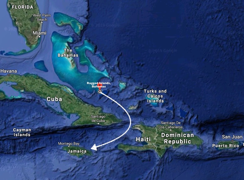
We had heard that the Windward Passage, the body of water separating Cuba, Haiti and Jamaica, could be notoriously like the Gulf Stream in its ability to quickly stack up nasty or even dangerous conditions when building wind directions oppose continually shifting currents.
Our strategy was similar to what we had used in crossing the Gulf Stream at Hatteras / Cape Fear… respect the stories you hear and shoot for a window that risks excessively calm conditions that may force motor-sailing over excessively breezy conditions that cause you to shit your pants.
Jamaica was just under four hundred nautical miles away, slightly more than three days sail.
Our departure Wednesday morning was greeted with very calm seas. Unfortunately, the wind was only seven to nine knots, and it slowed down from there.
By mid-afternoon, the wind indicator hovered at two knots, and our Perkins engine was the only thing carrying us over perfectly flat waters.
We would have been more than willing to sit; the surface conditions were certainly conducive. However, in the end we concluded that getting down to what we saw as potentially the diciest section of the Windward Passage, the area directly between Cuba and Haiti, while the wind was minimal was ultimately in our favor, even if we had to sacrifice a bit of diesel to achieve that.
We managed to shut off the engine for a spell, content to wring three to four knots of boat speed out of four to six knots of wind speed.


As we passed clear of Columbus Bank, and the floor of the ocean fell dramatically away from a depth of forty feet towards eight thousand feet, we could clearly see the shadow of Exit cast on the ocean floor more than one hundred feet below! A short time later, we crossed over the edge of an immense drop off. And then suddenly there was nothing below us but amazing shades of blue… split by beams of reflected sunlight trying to pierce into the depths.


And, once again, the ocean’s surface all around us was a magical shade of indigo.

Though we wrestled to keep the sails filled, in the end, to our dismay it was largely diesel power that propelled us until the following morning. The display on our weather chart indicated we were right in the middle of the only area for hundreds of miles that currently had breezes of less than five knots (just our luck).

By 3 a.m., the engine had been running for nearly ten of the past twelve hours. We were ready to concede that our plan was not viable as things stood. With no wind, there was no way we were going to motor four hundred miles to Jamaica. A slight detour farther to the east would put us at Great Inagua, where we could get provisions and wait until the winds returned. Or we could head slightly farther north and make for a tiny dot on the chart called Hogsty Reef.


Hogsty Reef is a minute atoll barely breaking the ocean surface in the middle of the open Atlantic. The coral walls that comprise its outer ring plummet down thousands of feet while inside the depth is only about twenty feet. Because of its exposed nature and zero protection, the location is tenable as an anchorage in only the calmest of conditions… like now.
We decided to roll the dice. If we had to motor, it would take seven extra hours both ways, which would suck. But it would also provide the perfect conditions for anchoring overnight. For now, we could raise the sail and kill the engine, content to move along at a slow pace.
Its difficult to describe exactly how it sounds after being underway all night long offshore under engine power, to finally shut the engine off and, under only sail power, think wow… what a difference. Only to realize that the propeller still spinning beneath the hull is creating its own noise… so you momentarily put the transmission in reverse creating near absolute silence and immediately think WOW… WHAT A DIFFERENCE!
A six a.m. sunrise and a new day…


After the previous night, even seven to nine knots of wind seemed like a gift.
By nine a.m., we had definitively altered our course to Hogsty Reef (prior to that we had been experiencing more of a non-committal steering in the general direction of Hogsty Reef). A choice had been made. No increase in wind in the forecast for the next couple of days… new plan.
However, less than two hours later, that new plan disintegrated.
NNW winds picked up out of nowhere to the tune of fifteen to seventeen knots… holy shit! And, just like that… wham! We’re doing better than eight knots speed over ground. Only, the seas are starting to kick up quite quickly.
It didn’t take long to realize the Hogsty Reef option had just been taken off the table… bummer. On the up side, the engine was off and we were flying along with only the genoa out.
The upside of downwind sailing is undoubtably comfort level. Fifteen knots of wind from behind feels more like ten, and sliding atop three to six foot following seas is preferable any day to pounding through four foot waves while getting hit with fifteen knots of wind on the nose!
We altered course away from Hogsty Reef. The current surface conditions would never allow for anchoring and would take a while to settle back down again even if the wind dropped off. For now, we could return back to a course towards Jamaica and reassess the conditions as we passed Great Inagua. If the wind died again, we could stop there.
Yet, when we unfurled the genoa and shut down the engine just after eight a.m., we had unknowingly set the stage for the rest of the passage to Jamaica. For the next fifty four hours, we ran mostly within forty degrees of dead downwind under power of sails only. Our engine didn’t get used again until we were about to enter the bay at Port Antonio, Jamaica.
What a difference twenty-four hours can make in our log entries…
9:00 – Winds appear to be dying over next couple of days; making for Hogsty Reef
10:30 – Making for Matthew Town on Great Inagua. Squalls making sea conditions untenable for Hogsty
13:00 – GPS track looks more like someone learning controls on an Etch-A-Sketch than a sailboat but back on course for Jamaica mon!
17:50 – Brilliant sailing for past six hours; what a change from this morning. In 10,000ft. of water. Approaching Windward Passage.
1:45 – 13nm off the coast of Cuba (1nm outside Cuba’s territorial waters)
10:00 – Now in the Caribbean Sea – may be first time Exit has been in this part of the world.

By 1:30 that afternoon we had rounded the southeastern tip of Cuba and passed within thirty five nautical miles of Guantanamo Bay, plenty close enough for us.
We’d been seeing fifteen to twenty knots of wind for over twenty four hours and it would remain like that for the next twenty four hours. Exit sped along comfortably atop the three to six foot following seas, which looked uglier than they felt.
As we approached to within nearly ten miles of Jamaica, an ominous stretch of very dark clouds lined up across the horizon, directly in our path. Almost as though a final gauntlet was being thrown down before we would be allowed to reach our destination.
But our radar revealed that we were actually looking at a very deceptively narrow band of storm clouds.

Slowly, in the distance… through the hostile looking, though largely benign, cloud cover… a dark mass began to appear low on the horizon. As it began to take form, the color slowly shifted from gray to green. The cry “land ho” went out.
Jamaica!


As we approached Port Antonio, we were immediately struck with the stark contrast the lush, green, mountainous terrain before us provided against the low lying, often inhospitably rugged and desolate Bahamas we had just come from.
Once inside the East Bay, conditions completely calmed down. As Kris circled around while I dropped the mainsail, she had to dodge a large number of coconuts, branches, and rubbish that was floating about in the bay. Initially, this seemed a bit shocking to us, until we realized it was the result of river runoff from the nearby mountains.
Our Bahamas courtesy flag, flying under the starboard spreader (which was now little more than a patch of torn cloth) had already been replaced with the yellow quarantine flag, which we had to fly until we cleared Customs.
In the Bahamas, we were able to anchor, then have one person dinghy ashore to visit the Customs office and Immigration office, where all the paperwork was dealt with.
In Jamaica, the Customs and Immigration officers come to your boat… slightly intimidating the first time, to say the least.
We had to tie up at the dock of the Errol Flynn Marina, run by the incredibly helpful and hard working Dockmaster George.

Clearing in turned out to be a rather painless process. About ten pages of forms and paperwork to be filled out. A visit from the Customs officer. A visit from the Immigration officers. No searches. No hassles. A lot of questions.
Then, after clearing in with the officials, a visit from a Jamaican named Presley who can help with whatever you need… Work on the boat? No problem mon. Go on a tour? No problem mon. Jamaican courtesy flag? US$10. Enough ganja to fill a mason jar? US$50… a weed magnet.
*****
Wandering around Port Antonio… a somewhat edgy but very friendly town that reminded us a lot of Semporna in Malaysia.
Not a cruise ship destination at all, Port Antonio felt more isolated from the typical tourist hustle… more laid back and certainly more authentic.
It just so happened our arrival coincided with the final days leading up to the local election. A much more festive and involved affair than anything we would ever see in the States, we got to experience music booming across the water of the bay until dawn for our first four nights.
A bit annoying? Possibly… but certainly better than the gunshots we heard people in Kingston got to listen to.


Local recommendations proved worth their weight in gold when it came to choosing the best jerk shacks to visit. Oddly enough, it was a little shack called Piggy’s Jerk Center for incredible jerk chicken. But Honest John, fifty-four years young cooking jerk pork for thirty-two years, proved the master. And not just jerk pork… jerk wild boar. My tongue was on fire while my stomach was in Heaven.


Oh, that moment when the engine goes off! We just motored 13 hours straight from Gloucester through the Cape Cod Canal a few days ago and…ugh! Sailing, even slowly, is nice, but a Goldilocks wind from abaft is the best.
I’m loving the pics of you two enjoying yourselves.
LikeLike